
|
HIKING THE BEAUTIFUL TERRAIN OF SRI LANKA
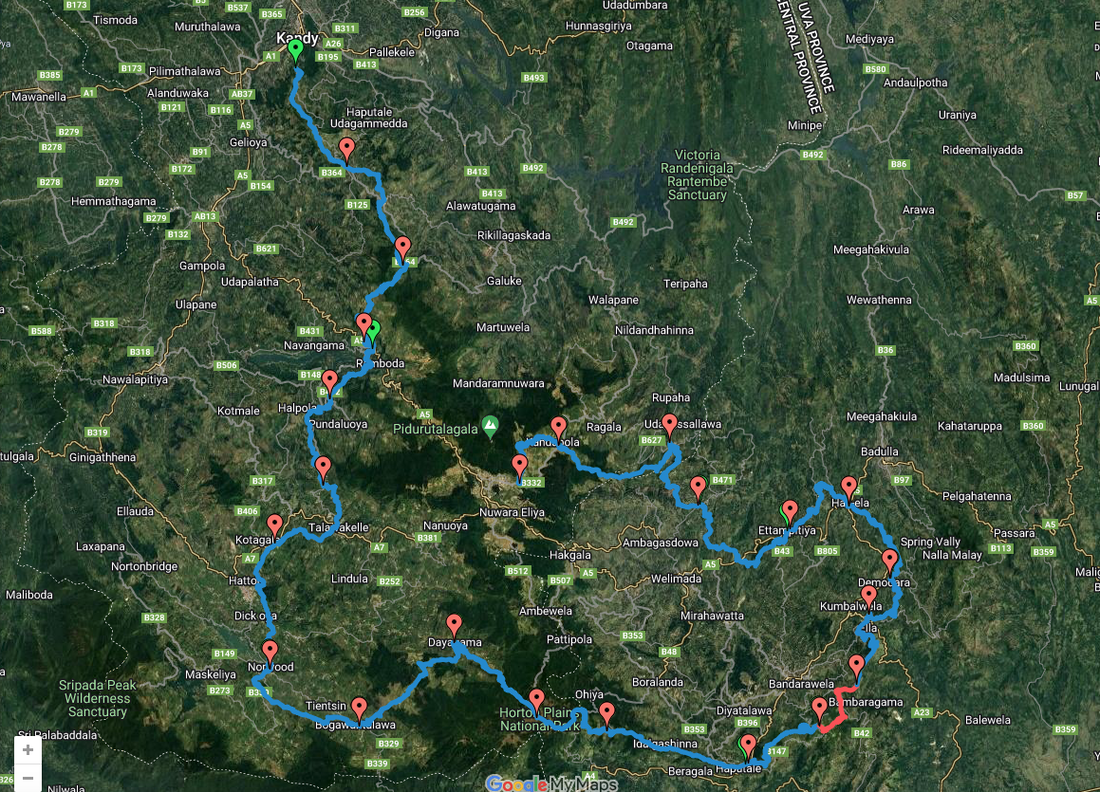
Designed for those interested in Hiking and Trekking the remote highlands of Sri Lanka The Pekoe trail is an absolute must for those interested in getting close to nature. What is the Pekoe Trail all about? Click on map below for a clearer view.
What is the Pekoe Trail all about?
The highlands of Sri Lanka are composed of a myriad of features, habitats, cultures, landscapes and rolling hills. An ideal way to take in the sights and sounds is to slow things down and take a walk along the roads that take you through all that you can see. Tea plantations were introduced to the central highland by the British and has become an integral attraction in the region. Seas of green tea fields spanning across the hills are a soothing sight for sore eyes and is best experienced on foot. The Pekoe trail is Sri Lanka’s brand new tourism product, a 300Km walking trail divided in to 23 sections that take you through roads less travelled. Done in either direction, the start/end points of the trail are Kandy and Nuwara Eliya. The trail takes you through Tea estates, Montane forests, Pine and Eucalyptus fortes, thorough remote upcountry villages, National parks, train stations and even bustling townships, albeit small. There are stages that suit every type of individual, from hardcore hikers/trekkers to novices taking on a new adventure for the 1st time! The trail has been developed conveniently to allow travelers to pick and choose the level of difficulty. If you want a bit of history, culture and wish to meet a few people along the way you can pick stages that intertwine immersive experiences. If you are an avid nature-lover and wish for a more solitary journey you can chose a stage that takes you through forest patches and protected areas. Stage 20, which can be done from Udupussellawa to Lunuwatte or in reverse, is 12Km long. At a slow pace while immersing yourself in the locality, you can commence the trail at 7:00 AM and complete by noon. Starting off at Udupussellawa, the trail takes you on a slight incline and through a tea estate leading to a narrow path and before you know it you are walking along a small path way with breathtaking views of the valley below. During this stage you walk through varying habitats and sceneries, that range from tea estates, Pine forests, Eucalyptus forests and small villages. Keeping a keen eye out for the wildlife you encounter along the route won’t disappoint as well. Each stage has its own unique characteristics for one to enjoy. Stage 20 is one for everyone and you get to experience a little bit of everything the hill country has to offer. Walking tourism steps beyond the conventional boundaries of hospitality by offering travelers of all ages an opportunity to truly experience the serenity of roads less traveled. The Pekoe trail sincerely invites visitors to experience its stunning vistas, curious wildlife and refreshing ambience. Await our next update as we complete more stages. STAGE ONE PEKOE TRAIL
Hantana to Galaha - ROUTE MAP
STAGE TWO PEKOE TRAIL
Galaha To Loolecondera - ROUTE MAP Elevation: 838 m Attractions - Kondagala/James Taylors seat. Kondagala mountain peak is a 300 m hike to the summit. It is situated close to James Taylor's cottage. STAGE THREE PEKOE TRAIL
Loolecondera To Thawalanthenna Elevation: 1177 m STAGE FOUR PEKOE TRAIL
Tawalanthenna To Kumbaloluwa Elevation: 960 m STAGE FIVE PEKOE TRAIL
Kumbaloluwa To Watagoda Elevation: 949 m STAGE SIX PEKOE TRAIL
Watagoda To Kotagala Elevation: 1349 m STAGE SEVEN PEKOE TRAIL
Kotagala To Norwood Elevation: 1245 m STAGE EIGHT PEKOE TRAIL
Norwood to Bogawantalawa Elevation: 1120 m STAGE TEN PEKOE TRAIL
Dayagama To Horton Plains Elevation: 1421 m MORE PEKOE TRAILS - TO BE CONTINUED
Start of The Pekoe Trail
Stage 11 Horton Plains to Udaweriya - ROUTE MAP
Start of The Pekoe Trail
Stage 12 Udaweriya To Haputale Elevation: 2127 m Start of The Pekoe Trail
Stage 14 St. Catherine (Lipton Seat) To ALLIMALE - ROUTE MAP
Start of The Pekoe Trail
Stage 15 Makulela to Ella
Start of the Pekoe Trail
Stage 19 Ettampitiya to Lunuwatte - ROUTE MAP
The Pekoe Trail Stage 22 Kandapola To Pedro Estate - ROUTE MAP Distance: 10.8 km
0 Comments
Leave a Reply. |
AuthorBeen anywhere recently? Please share your Travel story in my blog. Thank you. Archives
April 2024
Categories |
 RSS Feed


|
|
|

Copyright © 2011 Leisure World Tours